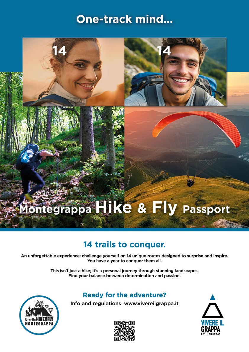
INAUGURAL MONTE GRAPPA HIKE & FLY PATENT
Inspired by the passion of paragliding enthusiasts who love to explore Monte Grappa on foot (hike) and soar above its breathtaking landscapes (fly).
What's it all about?
It's a personal challenge designed for those who love flying, hiking, and everything about the mountains. Think you need to be an athlete to participate? Not at all! To earn the MONTEGRAPPA HIKE & FLY PATENT, all you need is a good fitness level and the necessary skills to safely hike moderate mountain trails and paraglide.
What does it take to earn the MONTEGRAPPA HIKE & FLY PATENT?
You simply have to walk, strictly on foot and carrying your flight equipment on your back, without using any other means of transportation, some selected paths among the hundreds that cross Mount Grappa, choosing each time, as an (intermediate) arrival point, any of the take-off areas managed by the Consorzio Vivere il Grappa. Once the sail is opened and the flight has taken off, you must land at one of the two official landing sites "Garden" or "Paradiso" (which will be the final arrival point at the end of the performance).
How many trails are there and what level of challenge can I expect?
There are 14 trails in total, ranging from easy to expert. Two are very easy, eight are moderately challenging, and the final four are for those seeking a real adventure. There are also six take-off points: Costalunga (or Antenne), Campeggia, Stella, da Bepi (or Tappeti), Casette, and the legendary Panettone take-off point at 1,550 meters above sea level.
Do I need to complete all 14 trails to earn the PATENT?
No, there are three levels: BRONZE, SILVER, and GOLD.
To achieve the prestigious GOLD Patent, you must conquer all 14 trails.
For the SILVER Patent, complete 10 different trails, including at least two from the coveted Panettone take-off point.
To earn the BRONZE Patent, complete six distinct climbs, one starting from the iconic Panettone.
To verify your achievements, your GPS tracks will be recorded, capturing both your ascent and flight for each trail. Strictly follow the provided GPX tracks for your climbs, but feel free to explore longer flights during your descents, weather permitting.
Ready for a challenge? Sign up now!
INFORMATION POINTS
CONSORZIO VIVERE IL GRAPPA INFORMATION POINT - GARDEN RELAIS
Via Caose 22,
31030 Borso del Grappa (TV)
CONSORZIO VIVERE IL GRAPPA INFORMATION POINT - PIAZZA PARADISO
Piazza Paradiso 11,
31030 Borso del Grappa (TV)
Phone 0423 910526
E-mail: This email address is being protected from spambots. You need JavaScript enabled to view it.
Trails details
The 14 Hike & Fly trails are split into two groups: the first nine start at the Antica Abbazia Restaurant and Pizzeria, while the remaining six begin at the Garden Relais Restaurant. Both starting points are conveniently located in Semonzo, Borso del Grappa.
- GROUP 1 - TRAILS STARTING FROM ANTICA ABBAZIA (from 1 to 9 trails)
- GROUP 2 - TRAILS STARTING FROM GARDEN RELAIS (from 10 to 14 trails)
-

Hike & Fly 1 - Cavallo / Costalunga
Hike & Fly 1 - Cavallo / Costalunga

Cavallo/Costalunga
From the Antica Abbazia parking lot, take the dirt road that climbs gently northward along Valle Santa Felicita. Just over a kilometer from the starting point, turn left onto the CAI trail N°952, known as "cavallo", often used by runners to train for short but steep climbs (length 1800 m; elevation gain from the base of the trail to the Provincial Road Cadorna + 520 m).
At the end of the CAI N°952 trail, you'll reach the Provincial Road Cadorna. Turn left and follow the gentle downhill road (mind the traffic, especially on holidays) for a little over a kilometer until you arrive at the popular "Costalunga" or "Antenna" take-off site, located at 810 meters above sea level. This launch site can accommodate up to four paragliders at once and offers a gradual slope for easy take-offs. For the best flying conditions, launch with easterly winds. Multiple windsocks are available to help you assess wind direction.
- Distance: 4,5 km
- Ascent: +678 m
- Descent: -152 m
- Estimated hiking time: around 1 hour and 30 minutes
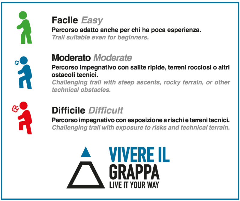
- Difficulty level: easy
- Take-off altitude: 750 m
- Take-off wind direction: E, SE
-

Hike & Fly 2 - Cavallo / Campeggia
Hike & Fly 2 - Cavallo / Campeggia

Cavallo/Campeggia
Unlike the first route, when you finish trail N°952 (Cavallo) and reach the Provincial Road Cadorna, instead of turning left, cross the road and take the dirt track ahead. Follow the signs to Malga Vittoria and then continue on the CAI trail N°950 until you reach Campo Solagna.
Cross the road again and follow the signs for the CAI trail N°954. In about 30 minutes, you'll arrive at the stunning Campeggia take-off site, located at 1,080 meters above sea level. This spacious grassy area is perfect for launching with multiple paragliders, especially with southerly winds. A windsock is provided.
- Distance: 6,2 km
- Ascent: +916 m
- Descent: -68 m
- Estimated hiking time: around 2 hours and 15 minutes
- Difficulty level: moderate
- Take-off altitude: 1080 m
- Take-off wind direction: S, SE, SW
-
Hike & Fly 3 - Nosellari / Campeggia
Hike & Fly 3 - Nosellari / Campeggia

Nosellari/Campeggia
We remain in the Valle Santa Felicita. However, after following the dirt road for about 2 km heading north along the bottom of the valley, turn left onto the CAI trail N°953, known as “nosellari”. From the base of the trail, located at about 380 m above sea level, continue for about 2 km until you reach a wooded plain at an altitude of 820 m.
At this point, take a dirt road on the right, following the GPX track scrupulously, as there are no CAI or other references on this section of the trail. The trail will first enter a dense coniferous forest and finally reach a firebreak dirt road (Sentiero due Valli) to follow on the flat for about 1 km, until you take the CAI trail N°954 on the left, at the end of which you will finally reach the Campeggia take-off.
- Distance: 5,3 km
- Ascent: +900 m
- DDescent: -41 m
- Estimated hiking time: around 2 hours and 15 minutes
- Difficulty level: moderate
- Take-off altitude: 1080 m
- Take-off wind direction: S, SE, SW
-

Hike & Fly 4 - Direttissima Campeggia
Hike & Fly 4 - Direttissima Campeggia

Direttissima Campeggia
From the Antica Abbazia parking lot, follow the dirt road along the valley floor for approximately 2 km. Once you pass the climbing gyms, you'll reach a fork in the road. Turn left onto the CAI trail N°954 and continue following this path until you arrive at the take-off area.
- Distance: 5,7 km
- Ascent: +873 m
- Descent: -28 m
- Estimated hiking time: around 2 hours and 15 minutes
- Difficulty level: moderate
- Take-off altitude: 1080 m
- Take-off wind direction: S, SE, SW
-

Hike & Fly 5 - Scalon / Trincee / Campeggia
Hike & Fly 5 - Scalon / Trincee / Campeggia

Scalon/Trincee/Campeggia
This is one of the most evocative of all 14 H&F trails, as in its final part it runs for about a kilometer along the trenches of the second Italian lines, built during what is still remembered as one of the most terrible conflicts that struck humanity: the First World War. This fifth route also follows the entire Valle Santa Felicita, leaving behind the climbing gyms to reach the usual final junction, from which you turn right onto the CAI trail N°180.
From the junction, you follow the first 500 meters along a steep channel enclosed between two steep rock walls, known as SCALON. The trail then continues into the woods, becoming gradually less demanding but always with a slight and constant climb.
At a second fork, we will leave trail 180 on the right, to continue along the valley, which from here on becomes increasingly narrow, on the CAI trail N°970. At a third junction, which we will encounter a little over a kilometer from the previous one, we will leave the CAI trail N°970 to take a left onto an unmarked trail.
For this reason, from this point on you will have to rely strictly on the GPX track, which, first through a dense coniferous forest and then along the trenches of the First World War, will lead you to the Campeggia take-off.
- Distance: 7,2 km
- Ascent: +964 m
- Descent: -112 m
- Estimated hiking time: around 2 hours and 30 minutes
- Difficulty level: difficult
- Take-off altitude: 1080 m
- Take-off wind direction: S, SE, SW
-
Hike & Fly 6 - Sentiero 100 / Stella
Hike & Fly 6 - Sentiero 100 / Stella

Sentiero 100/Stella
A fun route that follows, in its middle section, the first and challenging two kilometers of the famous CAI trail N°100. The starting point, as always, is the Antica Abbazia parking lot, from where you follow the usual dirt road along the valley floor, which you leave after a little over a kilometer, in favor of the CAI trail N°100 that you will find on the right with respect to the uphill direction.
Following the CAI trail N°100, within about an hour from the moment you left the dirt road, or at an altitude of about 840 m above sea level, you reach a firebreak mule track. Taking the mule track downhill, and therefore southwards, in just under 1 km you will reach the Provincial Road Giardino and through this, still downhill, to the large STELLA take-off area located at about 770 m above sea level.
Take-off recommended with winds from the south quadrants, which lends itself to the simultaneous opening of many gliders. Multiple windsocks are present.
- Distance: 5,0 km
- Ascent: +712 m
- Descent: -221 m
- Estimated hiking time: around 1 hour and 30 minutes
- Difficulty level: moderate
- Take-off altitude: 717 m
- Take-off wind direction: S, SE, SW
-
Hike & Fly 7 - Sentiero 100 / Casette
Hike & Fly 7 - Sentiero 100 / Casette

Sentiero 100/Casette
This route follows the same track as N°6 until, crossing the mule track at 840 m above sea level, instead of turning right towards the STELLA take-off, you turn left, continuing on the CAI trail N°100, slightly uphill until you cross a trail (not CAI) on the right, after about one kilometer, with indications for Malga Col Serai.
Taking this new trail (follow GPX track), in about twenty minutes you will reach the wide CASETTE take-off, located at an altitude of about 1000 m above sea level, suitable for opening multiple gliders and recommended with winds from the WEST quadrants. Windsock present.
- Distance: 6,3 km
- Ascent: +887 m
- Descent: -110 m
- Estimated hiking time: round 2 hours and 5 minutes
- Difficulty level: moderate
- Take-off altitude: 980 m
- Take-off wind direction: W, SW
-

Hike & Fly 8 - Sentiero 100 / Panettone
Hike & Fly 8 - Sentiero 100 / Panettone

Sentiero 100/Panettone
Perhaps the most beautiful of all 14 selected routes for this patent. It follows the entire CAI trail N°100, offering breathtaking views of the vast Po Valley to the south and the Alpine arc to the north, ending at the PANETTONE take-off, at an altitude of 1550 meters above sea level.
Note: for those who don't frequently visit Mount Grappa (and weather permitting), once you reach the take-off area, we recommend you grit your teeth for a little longer. In fact, continuing for another twenty minutes (always along the CAI trail N°100), you will reach the Sanctuary located at the top of the mountain, which houses the remains of thousands of Italian and Austrian soldiers who fell at the front during the First World War. We are sure that this little "detour" will not only make your H&F experience even more "wonderful", but will also give you the chance to breathe in a magical atmosphere that only Mount Grappa can offer.
The large Panettone take-off is recommended with winds from the east, south, and west quadrants and is suitable for the simultaneous launch of multiple gliders. A windsock is present.
Note: in case of westerly winds, be careful of the depressions and holes immediately downstream of the take-off area.
- Distance: 11,3 km
- Ascent: +1511 m
- Descent: -177 m
- Estimated hiking time: around 4 hours
- Difficulty level: difficult
- Take-off altitude: 1550 m
- Take-off wind direction: E, S, W
-

Hike & Fly 9 - Direttissima Stella
Hike & Fly 9 - Direttissima Stella

Direttissima Stella
The last of the 9 H&F routes starting from the Antica Abbazia, this trail is the most popular for those who want to quickly reach the first take-off area available with winds from the south quadrants, but also don't want to miss out on the joy of a nice and challenging climb through the woods.
This trail, although classified as "easy" due to its short length (only 2.2 km), has a never trivial slope. It is also advisable to pay attention to the final part of the route, when the trail forces you to cross a fenced green area, usually used for grazing donkeys and goats.
These are docile animals and accustomed to "hiker traffic", so they are absolutely harmless, but if you are not used to direct contact with "quadrupeds" we recommend leaving the trail where it intersects the Provincial Road Gen. Giardino at the eleventh hairpin bend, following which you can quickly reach the STELLA take-off point.
- Distance: 2,3 km
- Ascent: +558 m
- Descent: -67 m
- Estimated hiking time: around 1 hour
- Difficulty level: easy
- Take-off altitude: 710 m
- Take-off wind direction: S, SE, SW
-

Hike & Fly 10 - Garden / Tappeti
Hike & Fly 10 - Garden / Tappeti

Garden/Tappeti
Also known as the "40 hairpin turns trail," this is certainly the most famous and frequented H&F route on Mount Grappa. Fast, with a "moderate" length and elevation gain, and a constant gradient for almost its entire development, this tenth Hike itinerary ends at the new TAPPETI take-off point, at an altitude of about 850 meters. Attention: although very popular, this is not a CAI trail, so it is highly recommended to use the GPX track.
The take-off area, in synthetic grass, allows for the opening of 4 gliders simultaneously, and is recommended with winds coming from the SOUTH quadrants. Multiple windsocks are present.
- Distance: 4,5 km
- Ascent: +760 m
- Descent: -85 m
- Estimated hiking time: around 1 hour and 20 minutes
- Difficulty level: easy
- Take-off altitude: 830 m
- Take-off wind direction: S, SE, SW
-

Hike & Fly 11 - Garden / Kiki / Tappeti
Hike & Fly 11 - Garden / Kiki / Tappeti

Garden/Kiki/Tappeti
This route offers a more demanding alternative to trail N°10 (Garden/Tappeti), sharing the same ending. Compared to the previous trail, this one presents greater challenges, particularly in the middle section where you'll encounter some steep climbs. From the third kilometer onwards, while not an official CAI trail, the route is clearly marked with red paint.
However, especially on steeper sections where you might be focused on your footing, pay close attention to the trail as the markings can be less visible.
- Distance: 4,0 km
- Ascent: +740 m
- Descent: -68 m
- TEstimated hiking time: around 1 hour and 30 minutes
- Difficulty level: moderate
- Take-off altitude: 830 m
- Take-off wind direction: S, SE, SW
-

Hike & Fly 12 - Garden / Prati / Tappeti
Hike & Fly 12 - Garden / Prati / Tappeti

Garden/Prati/Tappeti
An interesting and panoramic route that in its middle section crosses horizontally the Valle Cornosega (or Valle dei Delta), flanking steep limestone towers and offering suggestive views of the plain below. For the first two kilometers, the route runs on a low-traffic asphalt road. Nevertheless, it is recommended to always pay attention to passing vehicles.
From the third kilometer onwards, the route follows the CAI trail N°190 with a good slope, which is abandoned shortly before reaching the "Prati di Borso" meadows, at an altitude of 700 meters above sea level, to begin the crossing of the Valle Cornosega.
From this point on, and for the following 2 kilometers, the route alternates between pleasant sections of slight descent and others of slight ascent, in a continuous, fast and fun up and down. Having finished crossing the Valle Cornosega, the route rejoins itinerary N°10 (Garden/Tappeti), at the 40th hairpin bend, sharing with it the final section until reaching the Tappeti take-off point.
- Distance: 7,4 km
- Ascent: +986 m
- Descent: -314 m
- Estimated hiking time: around 2 hours and 15 minutes
- Difficulty level: moderate
- Take-off altitude: 830 m
- Take-off wind direction: S, SE, SW
-

Hike & Fly 13 - Garden / Legnarola / Panettone
Hike & Fly 13 - Garden / Legnarola / Panettone

Garden/Legnarola/Panettone
Demanding ascent to the most coveted paragliding launch site. In its initial part, the route follows the same path as itinerary N°12. However, unlike the latter, upon reaching the junction at 700 meters above sea level that leads to the Valle Cornosega on the left, this new itinerary continues on the CAI 190 trail, branching off at an altitude of 825 meters in favour of the dirt road that gently ascends to the right, crossing the so-called "Prati di Borso" meadows. After about 1 km, at the first left-hand bend at an altitude of approximately 920 meters, take the CAI 197 trail, which, penetrating the forest with a constant and never trivial slope, leads all the way up to Mount Legnarola, at an altitude of about 1300 meters, connecting with the CAI 100 trail.
From here on, the scenery becomes increasingly suggestive. To the right, the immense panorama of the vast Po Valley, which on the clearest days allows for a truly unique view: from the faraway Apennines, to the nearby Euganean and Berici Hills, and finally to the Venice Lagoon in the EAST/SOUTH/EAST direction. On the opposite side, the view of the Alpine arc is no less spectacular: from right to left, we will admire the Friulian Dolomites, the nearby Feltrine Dolomites, the massif of the Pale di San Martino, ending at the Lagorai and, finally, the Asiago plateau, in a WEST direction. And to hold, like a kind of stage, all these marvellous peaks, the immense grassy expanses of Mount Grappa, here and there embroidered with the scars of trenches and the craters of shells, as a perpetual testimony to the bloody battles that took place here, especially during the last year of the First World War.
Finally, reaching the Panettone launch site, at an altitude of 1550 meters above sea level, you can finally take off towards the plain below, with winds from the EAST, SOUTH and WEST quadrants.
- Distance: 10,6 km
- Ascent: +1460 m
- Descent: -61 m
- Estimated hiking time: around 3 hours and 50 minutes
- Difficulty level: difficult
- Take-off altitude: 1550 m
- Take-off wind direction: E, S, W
-

Hike & Fly 14 - Garden / Prati/ Colombera / Panettone
Hike & Fly 14 - Garden / Prati/ Colombera / Panettone

Garden/Prati/Colombera/Panettone
The last of the 14 challenges, this route follows itinerary N°13 for the first 6.5 km, up to the hairpin turn at 920 meters above sea level at the end of the Prati di Borso meadows. It then continues along the CAI trail N°102, which with its constant ups and downs eventually meets the CAI trail N°104 at an altitude of 1.115 meters. Following this new trail uphill, the route becomes significantly steeper. Another 300 meters of ascent will reward you with the stunning panoramic views from Monte Colombera (1,431 meters). From here, connecting with the CAI trail N°100, you'll quickly reach the Panettone launch site.
- Distance: 11,4 km
- Ascent: +1624 m
- Descent: -224 m
- Estimated hiking time: around 4 hours and 15 minutes
- Difficulty level: difficult
- Take-off altitude: 1550 m
- Take-off wind direction: E, S, W